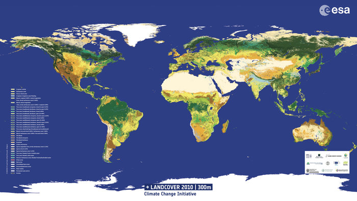
A global land cover by ESA Global Monitoring of Essential Climate Variables (aka ESA Climate Change Initiative) for the epochs 2000, 2005, and 2010.
The land cover map has been produced using MERIS images that have 300m resolution and 13 surface reflectance channels. A preview is available from here.
These data are very important for climate change studies because land cover is a non-climatic driver of climate change.
 |
| from http://www.esa.int/spaceinimages/Images/2014/10/Land_cover_2010 |
The following is the classification legend based on the UN Land Cover Classification System (from ESA):
- 0 No Data
- 10 Cropland, rainfed
- 11 Herbaceous cover
- 12 Tree or shrub cover
- 20 Cropland, irrigated or post‐flooding
- 30 Mosaic cropland (>50%) / natural vegetation (tree, shrub, herbaceous
- 40 Mosaic natural vegetation (tree, shrub, herbaceous cover) (>50%) /
- 50 Tree cover, broadleaved, evergreen, closed to open (>15%)
- 60 Tree cover, broadleaved, deciduous, closed to open (>15%)
- 61 Tree cover, broadleaved, deciduous, closed (>40%)
- 62 Tree cover, broadleaved, deciduous, open (15‐40%)
- 70 Tree cover, needleleaved, evergreen, closed to open (>15%)
- 71 Tree cover, needleleaved, evergreen, closed (>40%)
- 72 Tree cover, needleleaved, evergreen, open (15‐40%)
- 80 Tree cover, needleleaved, deciduous, closed to open (>15%)
- 81 Tree cover, needleleaved, deciduous, closed (>40%)
- 82 Tree cover, needleleaved, deciduous, open (15‐40%)
- 90 Tree cover, mixed leaf type (broadleaved and needleleaved)
- 100 Mosaic tree and shrub (>50%) / herbaceous cover (<50%)
- 110 Mosaic herbaceous cover (>50%) / tree and shrub (<50%)
- 120 Shrubland
- 121 Evergreen shrubland
- 122 Deciduous shrubland
- 130 Grassland
- 140 Lichens and mosses
- 150 Sparse vegetation (tree, shrub, herbaceous cover) (<15%)
- 152 Sparse shrub (<15%)
- 153 Sparse herbaceous cover (<15%)
- 160 Tree cover, flooded, fresh or brakish water
- 170 Tree cover, flooded, saline water
- 180 Shrub or herbaceous cover, flooded, fresh/saline/brakish water
- 190 Urban areas
- 200 Bare areas
- 201 Consolidated bare areas
- 202 Unconsolidated bare areas
- 210 Water bodies
- 220 Permanent snow and ice
The land cover data are freely available from the online viewer. Also, the land cover change, MERIS surface reflectance, water bodies, and land surface seasonality are available.