Minor Update: Semi-Automatic Classification Plugin v. 5.1.5

This post is about a minor update for the Semi-Automatic Classification Plugin for QGIS, version 5.1.5.


Following the changelog:
-added option for maximum result number in Landsat, Sentinel-2, and ASTER
download

How to identify Sentinel-2 granule zones using a shapefile

The identification of Sentinel-2 granule zones can be useful for searching Sentinel-2 images using the Semi-Automatic Classification Plugin (SCP).
It is possible to download a shapefile containing the Sentinel-2 zones.


Major Update: Semi-Automatic Classification Plugin v. 5.1.0

This post is about a major update for the Semi-Automatic Classification Plugin for QGIS, version 5.1.0.


Following the changelog:
-added toolbar for editing raster
-fixed issue in sorting and removing bands in the Band set
-various bug fixing

Land Cover Signature Classification: a New Method using SCP

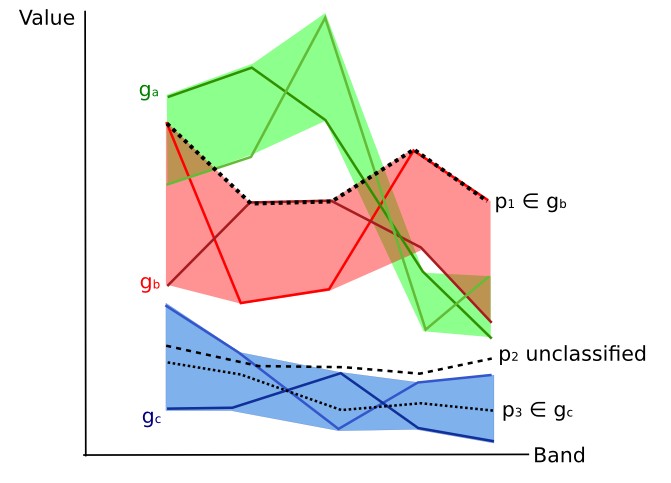
This tutorial is about the an innovative method of classification: Land Cover Signature Classification. This method was developed for the Semi-Automatic Classification Plugin (SCP), and it is based on the definition of spectral ranges (thresholds). A pixel belongs to class X if pixel spectral signature is completely contained in the spectral region defined by class X. For more information read this.


For this tutorial, it is assumed that one has the basic knowledge of SCP and Basic Tutorials.
Following the video of this tutorial.
Newer posts Older posts