SCP Questions of This Month: December

This post is a collection of questions and answers about the Semi-Automatic Classification Plugin (SCP) and remote sensing which were discussed in the Facebook group and the Google+ Community this month.
These questions vary from supervised classification technique to software issues, and can be useful to the readers of this blog for solving issues about the use of SCP.

SCP Questions of This Month

This post is a collection of questions and answers about the Semi-Automatic Classification Plugin (SCP) and remote sensing which were discussed in the Facebook group and the Google+ Community this month.
These questions vary from supervised classification technique to software issues, and can be useful to the readers of this blog for solving issues about the use of SCP.

A useful tutorial in Ukrainian about the Semi-Automatic Classification Plugin

I have recently posted about a series of video tutorials in Portuguese about the Semi-Automatic Classification Plugin (SCP). Tutorials are very useful for understanding remote sensing and how to work with SCP.
I am very grateful to everyone who makes tutorials in languages other than English, because the non-English speaking audience can understand SCP more easily. In this post I am glad to show a video tutorial in Ukrainian. Also, other useful tutorials in Ukrainian are available in the YouTube channel Gis For SFMU.
The video tutorials is titled "Основи дешифрування плагіном Semi-Automatic Classification 5.0 " and it is a basic tutorial about the land cover classification of a Landsat image.

A series of tutorials in Portuguese using the Semi-Automatic Classification Plugin for QGIS

In the past few years, I have written several tutorials about the Semi-Automatic Classification Plugin for QGIS, because documentation availability is fundamental for fostering education in remote sensing and GIS, also easing the work with SCP.
My tutorials are in English in order to reach a wider audience, but I am very pleased when other researchers develop tutorials in other languages.
In particular, in this post I am glad to show you several tutorials in Portuguese by Professor Gonçalo Vieira (also check his youtube channel for other tutorials) using SCP.

In particular the first video is titled "Classificacao supervisionada de imagens Sentinel-2 com QGIS e SCP" about the land cover classification of Sentinel-2 images.


Minor Update: Semi-Automatic Classification Plugin v. 5.2.1

This post is about a minor update for the Semi-Automatic Classification Plugin for QGIS, version 5.2.1.


Following the changelog:
-implemented Sentinel-2 download from AWS
-changed default Sentinel-2 service https://scihub.copernicus.eu/dhus
-added show plugin button in SCP menu

Major Update: Semi-Automatic Classification Plugin v. 5.2.0

This post is about a major update for the Semi-Automatic Classification Plugin for QGIS, version 5.2.0.


Following the changelog:
-new tool for cross classification, calculating cross raster and cross area
between a classification and a reference shapefile or raster
-tif files allowed as input for Sentinel-2 preprocessing
-in Batch tool begin with # can be used for comments
-in Band calc new variables for output names, #BANDSET# for name of the first band in the bandset and #DATE# for the current date and time
-in Batch calc fixed NoData calculation

From Image Download to NDVI Calculation in One Move: SCP Batch

This tutorial describes the easy steps for downloading multiple satellite images (Download images), converting the DN values to reflectance, and automatically calculate NDVI (i.e. Normalized Difference Vegetation Index).
In particular, the SCP tools are intertwined through options in the plugin interface, allowing for the definition of an automatic workflow. The same phases of this tutorial can be adapted to automatically calculate any spectral index for several satellite images. Finally, some of the Batch functions are illustrated, which allow for the processing of already downloaded images.

How to install SCP from the official repository

This post describes how to install Semi-Automatic Classification Plugin (SCP) from the official GitHub repository (master).
I often release SCP updates to the GitHub repository that provides always the latest SCP version for download. You can read the changelog of new versions from here.


In case you need a new version of SCP before the availability thereof in the QGIS repository, you can add the SCP repository to QGIS and install the master version. Moreover, this master version in the SCP repository can be installed along with the version available in the QGIS repository.

Minor Update: Semi-Automatic Classification Plugin v. 5.1.5

This post is about a minor update for the Semi-Automatic Classification Plugin for QGIS, version 5.1.5.


Following the changelog:
-added option for maximum result number in Landsat, Sentinel-2, and ASTER
download

How to identify Sentinel-2 granule zones using a shapefile

The identification of Sentinel-2 granule zones can be useful for searching Sentinel-2 images using the Semi-Automatic Classification Plugin (SCP).
It is possible to download a shapefile containing the Sentinel-2 zones.


Major Update: Semi-Automatic Classification Plugin v. 5.1.0

This post is about a major update for the Semi-Automatic Classification Plugin for QGIS, version 5.1.0.


Following the changelog:
-added toolbar for editing raster
-fixed issue in sorting and removing bands in the Band set
-various bug fixing

Land Cover Signature Classification: a New Method using SCP

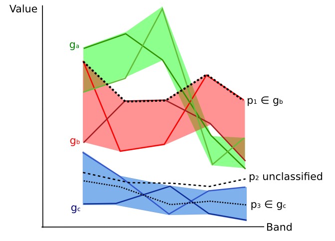
This tutorial is about the an innovative method of classification: Land Cover Signature Classification. This method was developed for the Semi-Automatic Classification Plugin (SCP), and it is based on the definition of spectral ranges (thresholds). A pixel belongs to class X if pixel spectral signature is completely contained in the spectral region defined by class X. For more information read this.


For this tutorial, it is assumed that one has the basic knowledge of SCP and Basic Tutorials.
Following the video of this tutorial.

Minor Update: Semi-Automatic Classification Plugin v. 5.0.13

This post is about a minor update for the Semi-Automatic Classification Plugin for QGIS, version 5.0.13.


Following the changelog:
-interface translation to Polish (thanks to Robert Szczepanek and Jakub Pękala)
-Band calc added button to import expressions from a text file (each line an
expression) with name and expression separated by ";" such as NDVI; ( "#NIR#" -
"#RED#" ) / ( "#NIR#" + "#RED#" ) @NDVI

Estimation of Land Surface Temperature with Landsat and ASTER

This post is about the estimation land surface temperature using Landsat Satellite and ASTER Satellite images. In this tutorial we are going to use a land cover classification for the definition of surface emissivity, which is required for the calculation of the land surface temperature. It is assumed that one has the basic knowledge of SCP and Basic Tutorials.
Our study area will be Paris (France), an area covered by urban surfaces, vegetation and agricultural fields.
Before downloading data, please watch the following video that illustrates the study area and provides very useful information about thermal infrared images, and their application (footage courtesy of European Space Agency/ESA). Also, a brief description of the area that we are going to classify is available here .

The thermal infrared band is particularly useful for assessing the temperature difference between the city and the surrounding rural areas, and studying the urban heat island phenomenon. We are going to use Landsat and ASTER images for the estimation of land surface temperature. For more information about the conversion of raster bands please read Conversion to At-Satellite Brightness Temperature. Following the video of this tutorial.

New release: Semi-Automatic OS v. 5

I have released a new version of the Semi-Automatic OS v. 5, a free virtual machine based on Debian Linux, for the land cover classification of remote sensing images. It includes the Semi-Automatic Classification Plugin (SCP) and QGIS, already configured along with all the required dependencies (OGR, GDAL, Numpy, SciPy, and Matplotlib).


The main features are:
  • based on Debian 8, available in 32 bit and 64 bit;
  • includes QGIS 2.8.2;
  • includes the Semi-Automatic Classification Plugin v. 5.0.8 - master, installed through the official master repository ( https://semiautomaticgit.github.io/SemiAutomaticClassificationPlugin/repository.xml ) which provides always the latest version of SCP;
  • includes the PDF version of the User Manual of the Semi-Automatic Classification Plugin and a sample dataset of Landsat image (available from the U.S. Geological Survey) and a Sentinel-2 image (© Copernicus Sentinel data 2016) which are the input for the two basic tutorials.

Minor Update: Semi-Automatic Classification Plugin v. 5.0.6

This post is about a minor update for the Semi-Automatic Classification Plugin for QGIS, version 5.0.6.


Following the changelog:
-fixed ROI creation issue whith multiband raster
-added plugin repository
-stack bandset now uses the first band name for the output

Minor Update: Semi-Automatic Classification Plugin v. 5.0.5 updated Sentinel-2 service


This post is about a minor update for the Semi-Automatic Classification Plugin for QGIS, version 5.0.5.


Following the changelog:
-changed default Sentinel-2 service https://scihub.copernicus.eu/dhus (requires user account)
-fixed issue #12 with translations
-fixed various issues

Translation of SCP Documentation and Interface: How to Get Involved

The Semi-Automatic Classification Plugin (SCP) can be translated from English to any language.
This is fundamental to improve the usability of SCP and your contribution is very important for the user community. Therefore, I invite you to translate the user manual and the program interface to your language.

I am very pleased that with the recent update of SCP v.5.0.4 I have included the complete translation of the interface to Spanish, mainly translated by Igor F. Dávalos Rojas (a sincere thank you).
Also, a partial interface translation to Polish is already available, thanks to Robert Szczepanek and his student Jakub Pękala who is working to complete the translation update to the new version 5 of SCP.
I would like also to thank everyone who is involved in the translation of the manual and the interface to other languages.

SCP Interface translated to Spanish

It is possible to easily translate the SCP user manual to any language, because it is written in reStructuredText as markup language (using Sphinx). To contribute to the translation of SCP to your language, please follow this guide.

Basic Tutorial 2: Supervised Classification of Land Cover using Sentinel-2 Images

This tutorial describes the main phases for the classification of images acquired by Sentinel-2 Satellite. In addition, some of the SCP tools are illustrated.
We are going to classify the following land cover classes:
  1. Water;
  2. Built-up;
  3. Vegetation;
  4. Bare soil.
Following the video of this tutorial.

Minor Update: Semi-Automatic Classification Plugin v. 5.0.3 for Sentinel-2 download

This post is about a minor update for the Semi-Automatic Classification Plugin for QGIS, version 5.0.3.


Following the changelog:
-fixed Sentinel-2 SSL download issue

Semi-Automatic Classification Plugin v.5.0 "Kourou" Released: Supervised Classification Tutorial

I am very glad to announce the availability of the new Semi-Automatic Classification Plugin (SCP) version 5.0, code name "Kourou" (dedicated to the Europe's Spaceport in French Guiana where Sentinel satellites are launched, see http://www.esa.int/Our_Activities/Launchers/Europe_s_Spaceport/Overview_of_Europe_s_Spaceport).
I have also updated the user manual that is available here.


In case the plugin is still not available inside QGIS Plugin Manager, you can perform a manual installation, following this guide.
Following the first basic tutorial of this new version.

Exploring the new features of Semi-Automatic Classification Plugin v.5.0 "Kourou"

I am glad to announce that the new Semi-Automatic Classification Plugin (SCP) version 5.0, code name "Kourou" (dedicated to the Europe's Spaceport in French Guiana where Sentinel satellites are launched, see http://www.esa.int/Our_Activities/Launchers/Europe_s_Spaceport/Overview_of_Europe_s_Spaceport) will be released on 1st of September.


Following the changelog:
-new interface
-new input file (extension .scp) which is a zip file containing the shapefile and signature list file
-possibility to create multipart ROIs (pressing CTRL + mouse click) and CTRL + Z for removing last part
-C ID is automatically incremented after saving a ROI
-function to merge ROI polygons from table
-new Land Cover Signature classification based on the range values of spectral signatures
-new tab for the definition of range values for Land Cover Signature classification
-in Landsat and Sentinel pre processing added option for calculations based on the band set
-new tab for PCA (Principal Components Analysis) of Band set
-in Band set added options for automatic calculation of virtual raster, stack of layers, build overviews, and Band calc expressions
-enhanced signature plot that allows for interactive definition of range values and new navigation (pan with left click and zoom with scroll or right click)
-enhanced Band calc allowing for the use of variables "#BLUE#" , "#RED#", and "#NIR#" in expressions
-Band calc option to use custom file names for multiple expression adding @fileName at the end of expression
-in Band calc added Decision rules for calculating raster based on conditions (e.g. "raster1 >0" or multiple rules separated by semicolon)
-added button for importing SCP file (polygons with automatic reprojection and spectral signatures), CSV, and external shapefile
-direct search of Landsat images from NASA CMR Search
-new tab for search and download of ASTER images L1T  from NASA Land Processes Distributed Active Archive Center
-new tab for conversion of ASTER images L1T
-new tab for manual raster editing
-new tab for classification sieve
-new tab for classification erosion
-new tab for classification dilation
-new tab for conversion from vector to raster (using a reference raster for pixel alignment)
-new tab for batch processing (Landsat conversion, Sentinel conversion,  ASTER conversion, Create band set, Classification, Split raster bands, Vector to raster, Clip multiple rasters, Accuracy, Land Cover Change, Classification report, Classification to vector, Reclassification, Classification sieve, Classification erosion, Classification dilation, Edit raster using shapefile, Band calc) and option for using a working directory (!working_dir!)
-new tab for editing RGB list
-improved settings of UL and LR points for area definition in several tabs (left click for UL point and right click for LR point)
-added service option for Sentinel-2 download mirrors (e.g. working with https://finhub.nsdc.fmi.fi , https://data.sentinel.zamg.ac.at)
-if available, Sentinel-2 granule preview are downloaded from the Amazon Web Services (http://sentinel-pds.s3-website.eu-central-1.amazonaws.com)
-results of image searching are added to the previous results in the table
-improved scatter plot
-ROI size (pixels) is calculated in the Signature details
-added button for calculation of spectral distances
-clip multiple rasters using shapefile and accuracy assessment now work also if shapefile and raster projections are different

Semi-Automatic Classification Plugin v. 5: Watch the Trailer

I have started developing the new version 5 of the Semi-Automatic Classification Plugin for QGIS.
This will be a major updated with several new functions and a revamped interface.

In particular, the interface will have a unified dock (merging the ROI dock and Classification dock of the previous version) to gain more space for the display of the image. Also, several tools will be moved to a toolbar for rapid access to ROI creation and classification previews.
Following a preview of the new interface (there could be changes in the final version of SCP).

Sentinel-2 Download Issues Using the Semi-Automatic Classification Plugin: Solved

Recently several users of the Semi-Automatic Classification Plugin (SCP) for QGIS reported errors that prevented the search and download of Sentinel-2 images.


The issues were caused mainly by the cryptographic protocols used for accessing data and the way the SCP tries to connect to the Copernics Data Hub (https://scihub.copernicus.eu).
In particular, the issues started after some recent changes of the Copernics Data Hub, when the protocols used for accessing data were upgraded (i.e. TLS v1.1+).

The SCP relies on Python for downloading Sentinel-2 images.
As described here https://docs.python.org/2/library/ssl.html the protocols TLS v1.1 and TLS v1.2 are available only in Python 2.7.9+ with openssl version 1.0.1+.
Unfortunately QGIS comes with a previous version of Python where TLS v1.1 and TLS v1.2 are not available. Therefore the Sentinel-2 download process fails.

A study about demographic growth and remote sensing presented at FOSS4G Argentina 2016


I was recently informed that the Semi-Automatic Classification Plugin (SCP) for QGIS is cited in an interesting paper (in Spanish) by Patricia Alejandra Rosell and Magalí Natalia Vicente (graduated at the Departamento de Ingeniería de la Universidad Nacional del Sur, Bahía Blanca, Argentina), which was presented at the FOSS4G Argentina 2016 (Conferencia de Geomática Libre Buenos Aires, Argentina. 5-9 de Abril), an important conference about free geographic software.
The authors used several Landsat images, processed using the SCP, in order to calculate spectral indices related to built-up, and estimating urban growth from 1986 to 2015 in the study area of Puan Partido (Buenos Aires Province, Argentina).

The NDVI calculated for 1986 (Rosell and Vicente, 2016)

OSGeo-Live 9.5 released: the Semi-Automatic Classification Plugin is included in QGIS plugins

OSGeo-Live is a very useful and popular distribution based on Lubuntu which includes fully-operational versions of Free Geospatial Software (more information here). OSGeo-Live is provided as bootable ISO-Images (for the operating system installation) and Virtual Machines (such as Semi-Automatic OS).

They have recently released the version 9.5 of OSGeo-Live. Of course, it includes QGIS 2.14 and many other programs such as SAGA and Orfeo Toolbox. I am very pleased that the Semi-Automatic Classification Plugin (SCP) version 4.9 is already installed inside the QGIS Plugins.

OSGeo-Live 9.5: SCP installed

This can be useful for workshops and training courses, also without having an internet connection, because everything is already installed and operational. OSGeo-Live also includes several sample datasets that can be used for testing programs.
In order to use SCP in QGIS, you need to activate it inside the Plugins (checking the option in the menu Installed). If an internet connection is available, I recommend to update the plugin to the latest version.

SCP running in OSGeo-Live 9.5

Many thanks to the OSGeo-Live team for including SCP also in this new version and for their effort in providing easy access to Free Geospatial Software.

Minor Update: Semi-Automatic Classification Plugin v. 4.9.2

This post is about a minor update for the Semi-Automatic Classification Plugin for QGIS, version 4.9.2.


Following the changelog:
-fixed Sentinel download from scihub.copernicus.eu/apihub to scihub.copernicus.eu/s2

From GIS to Remote Sensing Wishes You Happy 2016

In this first post of 2016 I would like to wish you a Very Happy New Year!
2015 has been an intense year for the remote sensing field, especially considering the launch of Sentinel-2 satellite, which is now acquiring wonderful images such as the following one (Rome, acquired on 18/12/2015).

Image of Rome, acquired by ‪‎Copernicus‬ ‪‎Sentinel-2‬ on December 18th 2015
Newer posts Older posts